Real time experimental moorings:
An OASIS in Monterey Bay, California
Francisco P. Chavez, Robert
Herlien and Gary Thurmond
Monterey Bay Aquarium Research Institute
Moss Landing, CA 95039
Updated by Mark D."Zorba"
Pickerill
Recent OASIS can being readied for M1 Deployment
The importance of time series in oceanographic research is clear. Time series measurements of physical and meteorological properties, currently taken throughout the globe, have allowed investigators to resolve the important scales of oceanic and atmospheric variability. With a few exceptions the current time series are primarily physical in nature (i.e., temperature). Biological and chemical oceanographers are now looking to continuous observations of biological and chemical properties so they can also determine the spectrum of variability in these fields and when taken concurrently with the physical and meteorological observations determine the relation to climate and ocean variability. Spatial coverage will ultimately come from observations made from space, but high-frequency temporal and added vertical coverage will need to come from moorings and drifters with arrays of in-situ sensors. The paucity of biological and chemical time series has been due, in part, to the lack of this type of instrumentation, however, increased effort has recently been placed on the development of chemical and bio- optical instrumentation for the collection of these time series. Realizing that advances in ocean sciences are limited by the lack of instrumentation and systems capable of collecting these time series, the Monterey Bay Aquarium Research Institute (MBARI) has established a vigorous developmental program geared at making these observations possible.
One of the goals of the program was to develop a new set of control electronics and software that would allow for the collection, storage, and telemetry of data from any of a wide range of scientific instrumentation. The controller, OASIS (Ocean Acquisition System for Interdisciplinary Science), and its deployment in moored and drifting systems, is the focus of the present contribution. Additional impetus for designing such a system were the increased need for real-time environmental information, the need to easily add new instrumentation as it came forward and the need to test new instrumentation with rapidity and in an environment that was well documented with respect to other properties. The ability to add devices is key when new instrumentation is being developed at a rapid rate. Testing of new instrumentation is best carried out on an easily accessible platform where a basic set of observations are routinely taken (temperature, salinity, wind speed and direction, etc.) so that data from the new instrumentation can be readily analyzed and interpreted. The advantages of two-way real-time telemetry are several-fold. It allows for quality control of data so as not to lose long, expensive mooring deployments. The data is immediately available for analysis, assimilation into models, and calibration of satellite sensors. The information provided in real-time by the system can be of tactical use for shipboard experiments, especially those geared at specific events. Finally, instruments can be accessed remotely so that sampling frequency can be modified according to needs or trouble- shooting performed without retrieval.
Objectives
The initial scientific and technical objectives were:
1) Establish a a platform for the deployment of a set of unattended sensors and samplers.
2) Design a general purpose controller that collects data from scientific instrumentation via multiple interfaces and then telemeters the information real-time.
3) Make continuous observations of physical, chemical and biological properties in Monterey Bay and the associated coastal central California ecosystem so as to describe time-varying aspects with increased resolution and over long periods of time.
4) Contribute to the improvement of mooring and unattended sensor technology, with emphasis on biological and chemical properties.
5) Provide groundtruthing for properties sensed from space.
System Design
The engineering objective of the mooring project was to develop a new set of control electronics and softwarethat would allow for the collection, storage, and telemetry of data from any of a wide range of scientific instrumentation. Considering the rapid rate of instrument development it was important to design a system capable of multiple interfaces. A general-purpose controller was designed so that it could interface to scientific instrumentation via any anticipated method, including:
- RS 232 (110 to 38400 baud);
- Analog voltage;
- Digital logic (5 volt TTL or CMOS);
- Frequency measurements, including pulse modulation;
- Power control (turn device on/off);
The controller, centered around the Intel 87C196 chip acquires data from the configured sensors, stores the data as required, and telemeters the data back to shore via packet radio. The controller is easily extensible and programmable. By extensible it is meant that new devices can be easily added. It is programmable, allowing the user to change parameters such as sample rate, interface parameters and telemetry parameters from shore. The controller has also proven useful for other applications and for acquisition of data from other platforms such as drifters.
The design of the OASIS board considered, in addition to extensibility, low power and reliability. At the current operating speed of 9.830 MHz (the CPU is capable of operating from 3.5-16 MHz) the board consumes 75 mAh/day @ 12V, which is small relative to consumption by the instrumentation. On the present moorings all power, provided by a lead acid battery (9-18V) recharged by an array of solar panels, is shunted through the controller.
The controller schedules a real time clock to put it to sleep and wake it up for its next task. There are three UART's on the board. One is on the 87C196 chip and serves either the terminal or the packet radio; the other two are external and serve the instrumentation. There are sixteen (16) latching relays for the two external UART's allowing for connection to the same number of serial devices. The original design encorporated only 8 relays, but it was found that the M1 site exceeded eight instruments, necessitating a second controller addition, but with the 1996 deployment one controller now has the capability of handling sixteen (16). The latching relays are used for reliability so that the system is completely isolated from the environment and/or sensors. Parallel I/O and bus expansion are also available on the board. Analog conditioning and the power switching circuitry are on a small "daughter" board. Memory on the controller, external to the CPU, is divided into three categories. A socketed 32K EPROM device contains the program code. So-called data or scratch RAM and logging RAM are used for program elements and data storage respectively. Current allocations are 24K and 1 MB. The use of small IDE hard hard drives for larger data storage applications is also been added in 1996. In the present (Monterey Bay) application data storage is only an issue if the telemetry link is down as all data are telemetered to shore every hour. However, for remote applications, such as MBARI's participation in Eq-Pac, all data can be stored on disk, greatly enhancing long term data aquisition capability.
Software
There are two major software efforts for the OASIS project, on the mooring and on shore. On the mooring the programs running on the 87C196 are written in C. The core of the code is a multitasking scheduler that controls wake up and interfaces with a series of drivers. There are drivers for the user interface, packet radio and each instrument. In this sense the programming is modular, so that if a new instrument is to be added, a new driver is developed and added to a table. In addition each driver has a generic set of parameters. There are a set of default parameters for each driver that are called from a table when the system boots or resets and these can be modified through the user interface either directly or over the packet radio link. The current C code occupies 25K of the available 32K of EPROM space. A significant aspect of the software is that it allows users to directly connect to serial devices via the user interface.
A typical set of operations is as follows. The clock wakes up the controller at a predetermined time. The scheduler starts the drivers that are on its list and then waits until they return with a task completed message. Once all tasks are completed the scheduler requests that the clock put it to sleep and wake it up for its next schedule of tasks. One particular task involves communication between a computer on shore and the controller. Currently the controller listens for the remote connection for twenty seconds once every ten minutes (under software control). Once communication is established the on shore computer requests all data since the previous request for data. The data from the instruments are uuencoded by the controller software to reduce the size of the files and therefore reduce storage and radio transmission time.
The collection of data from shore is automated by software running on a Hewlett-Packard workstation. The software is combination of C code, UNIX shell scripts and UNIX cron jobs. A cron job is initiated once an hour on the hour to request data, through shell scripts, from n (maximum number has been four when a drifter has been deployed) controllers deployed in Monterey Bay. The shell scripts request data from the controllers and then initiate a series of C programs that extract and decode the data files These programs apply calibrations and append the data to daily files ASCII in instrument-specific directories. Each file has a header that describes the contents of the file. Once daily, during off hours, the data files are concatenated into files that span the entire deployment period.
Instruments and their interface
The majority of instruments are interfaced via RS-232 and a few are analog. The thermistor chain, wind and compass are frequency measurements made by ATLAS but similar capability exists on OASIS and these measurements could be subsumed if desired. The most common serial interface consists of power, receive, transmit and ground. Because each instrument has its own particular attributes each interface is different and some require more software than others.
Instruments such as RDI's acoustic doppler current profiler (ADCP) and Biospherical's PRR-600 spectroradiometers broadcast data while others like the Seabird Seacat can provide data upon request. The interface characteristics of some of the core instruments are described in the next few paragraphs.
The ATLAS, ADCP, Seacat and the nitrate analyzer are stand-alone systems. ATLAS collects and stores meteorological and ocean temperature information once every ten minutes. Software in ATLAS has been modified from their standard use in the equatorial Pacific by PMEL so that the OASIS controller can access the ten minute data. Once every ten minutes, but not during the time ATLAS is collecting data, a control T is sent from OASIS to ATLAS and ATLAS responds by providing its last set of measurements.
The ADCP is programmed to take a measurement once every 15 minutes. Once the data acquisition and processing is finished the ADCP sends the data out through its serial line and stores it internally. OASIS listens for the ADCP data once every 15 minutes and collects it.
The Seacat is programmed to take a measurement every ten minutes and OASIS wakes it up and requests the last sample. A similar dialog exists between OASIS and the nitrate analyzer. The analyzer, run by a Tatletale IV, takes a measurement every five minutes and stores it. OASIS wakes it up once every thirty minutes and gets the data since the last request.
There are also several instruments that depend on OASIS for data collection and these include the GPS, Biospherical spectroradiometers and LICOR carbon dioxide (CO2) analyzers and photosynthetically active radiation (PAR) sensors.
The GPS receiver is turned on once every thirty minutes and three minutes of data are then collected and averaged by OASIS. For the PRR-600 spectroradiometers, OASIS turns on the power and listens for the data. There are three PRRs daisy-chained on one line that has the transmit and receive cables shorted so that all instruments can hear each other. Each instrument contains two CPUs (one for downwelling irradiance and one for upwelling radiance) and each CPU has a unique identifier. One scan of data from each CPU is transmitted sequentially and OASIS averages n scans (under software control) so that a truly synchronous measurement of irradiance and radiance at several levels can be accomplished.
For the MER series of spectroradiometers the units are turned on and programmed by OASIS on every sample, and the data collected after the instrument averages on board. In the current configuration the analog data from two near-surface Satlantic OCR-100 spectroradiometer are digitized by a MER 1010 along with data from an above water irradiance sensor.
The CO2 analyzer is turned on every hour by OASIS and given instructions as to what data to send. After allowing three minutes for the embedded thermoelectric cooler to reach equilibrium it requests a sample. Once every four hours a string sent to the instrument instructs it to actuate a valve so that both cells sample air. In addition OASIS turns on/off a small pump in an equilibrator that feeds ocean-derived gas to the analyzer. The PAR sensors are current generators, so after conversion from current to voltage on the daughter board the signal is digitized by OASIS.
Telemetry
The telemetry system used by the OASIS project is based on packet radios popularized by the amateur ham radio operators. On the mooring there is a miniature 1200 baud AX.25 terminal node controller (TNC) and a R-net 2 watt telemetry module. On shore and at a repeater site on Mount Toro rack-mounted systems with the same characteristics are deployed. Transmissions occur on the 460 MHz band and the present effective baud rate through the repeater is 2400 baud. At the current data collection rates the radio frequency is used on the order of 25% of the time so that throughput is not limiting.
There are currently two moorings deployed in and around Monterey Bay, California Since the offshore site is not within line of sight of the shore laboratory a repeater was deployed at 1000m elevation on Mount Toro. This increases the range of the telemetry system to on the order of 140 km from shore.
Mooring and drifter hardware.
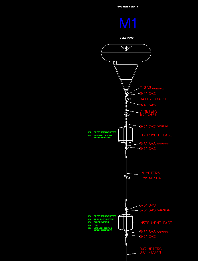
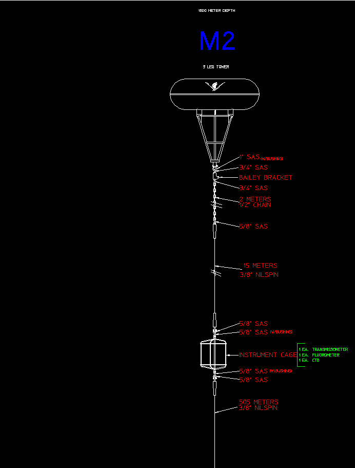
The OASIS controller has been deployed on three different sets of platforms. In the moored configuration, ATLAS and PROTEUS moorings were modified to allow for deployment of OASIS, a solar panel array, an elevator assembly for near surface instruments and cages were added subsurface at 10 and 20 m for additional instruments. The primary difference between ATLAS and PROTEUS is that the latter has a four leg tower and bridle (ATLAS has three) to accommodate deployment of an ADCP. Current deployments are an ATLAS-like mooring at the M2 site and a PROTEUS-like mooring at M1. Strategically the M1 site is considered the development site and M2 the site were "mature" technology is deployed. However, because of proximity to shore most of the instrumentation is deployed at site M1. This requires more power at M1 and the solar power array there consists of eight 10 watt panels while at M2 there is a three panel array. The solar energy is used to charge a 90 amp-hour lead acid battery capable of operating the system for two weeks without recharging. The battery is connected directly to OASIS and it (OASIS) provides power to all the devices. One exception is the marker light that receives power directly from the battery. Additional outlets are available on the battery.
Elevators have been built on both moorings to service the near-surface instruments. Service includes replacement of devices and removal of biological growth. Goose neck barnacles of the genus Lepas are a particularly severe problem that require regular attention.
Stainless steel cages are deployed at 10 and 20 m for instruments such as spectroradiometers, additional CTD sensors, nitrate analyzers, acoustic modem hydrophones, etc.
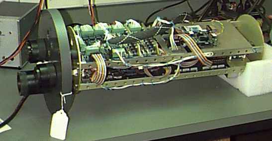
The OASIS electronics, including the packet-radio hardware and GPS receiver, is housed in a 8 1/2" OD PVC tube 24" long. An PVC face plate has been machined to hold three split connectors (6 each), dorn bushings for antenna coax, and a ball bearing feed through to allow pressurization of the can.
The OASIS can has also been deployed successfully on a drifter. In this configuration the can is bolted on to a ionofoam doughnut with about 100 lb. floatation. A stainless steel bridle allows for attachment of a stainless steel cage and a holey sock drogue similar to those used in WOCE drifters. In the drifter mode power is provided by D-cells. Ten (10) D-cells provide enough power for a GPS position every 15 minutes and a radio transmission every hour for 14 days. Up to 20 D-cells can be accommodated in the present can design.
Results to date
ATLAS moorings were first deployed at sites M1 and M2 in the waters adjacent to Monterey Bay in August 1989. The initial deployments were used to determine if these types of moorings could be maintained in a coastal environment, with heavy fishing pressure, for long periods of time. The sites were selected primarily for scientific reasons but after discussion with the local fishermen. The moorings have survived well to date and vandalism has not been an issue.
In 1992 the two moorings were re-deployed with novel sets of control electronics capable of assimilating data from multiple instruments and telemetering it real time via packet-radio and/or satellite. Data from a thermistor chain, meteorological instrumentation, CTD's with fluorometers and transmissometers, SeaWiFS-compatible spectroradiometers, an acoustic Doppler current profiler, a pCO2 sensor, nitrate analyzers, PAR sensors and diagnostic data (battery voltage, can pressure, etc.) are currently being assimilated and processed.
The reliability of OASIS has exceeded expectations. The OASIS data acquisition system has only experienced one period of down time in two years of operation due to the OASIS hardware and software. The problem was with a hardware component being underspecified and was easily corrected. Failure of the peripheral devices (instruments and telemetry) has far exceeded that of the controller.
A number of our original program objectives were met with the initial OASIS deployment:
* Establish a platform for deployment of unattended sensors;
* Design and construct a general-purpose telemetering controller;
* Make continuous physical, chemical and biological observations in Monterey Bay so as to describe their time-varying aspects;
* Characterize a variety of optical instruments in remote deployments. Real-time data is being collected at the highest rates ever achieved for a long-term ocean mooring system (Table 1) and many of these data are from instruments that have not previously been reported in real-time. OASIS, with its novel design, is one of the few mooring systems in the world where new instruments can be added with relative ease and their data quality- controlled in real-time. OASIS electronics have also been successfully deployed on a WOCE-like drifter with several instruments, including a Seacat and a nitrate analyzer.
The collection of biological time series concurrently with physical measurements has allowed for characterization of the coastal central California environment with resolution that had not been possible before. A notable result is the high but coherent variability in phytoplankton, the small microscopic plants that are the base of the ocean's food web. The comparison of data from a surface fluorometer with bi-weekly shipboard observations at the M1 site shows that many of the bloom to bust cycles of plants in this environment are missed by sampling at the frequencies that commonly possible with shipboard efforts. This is particularly true for coastal environments and the present observations are an example of the need for continuous observations of ocean properties.
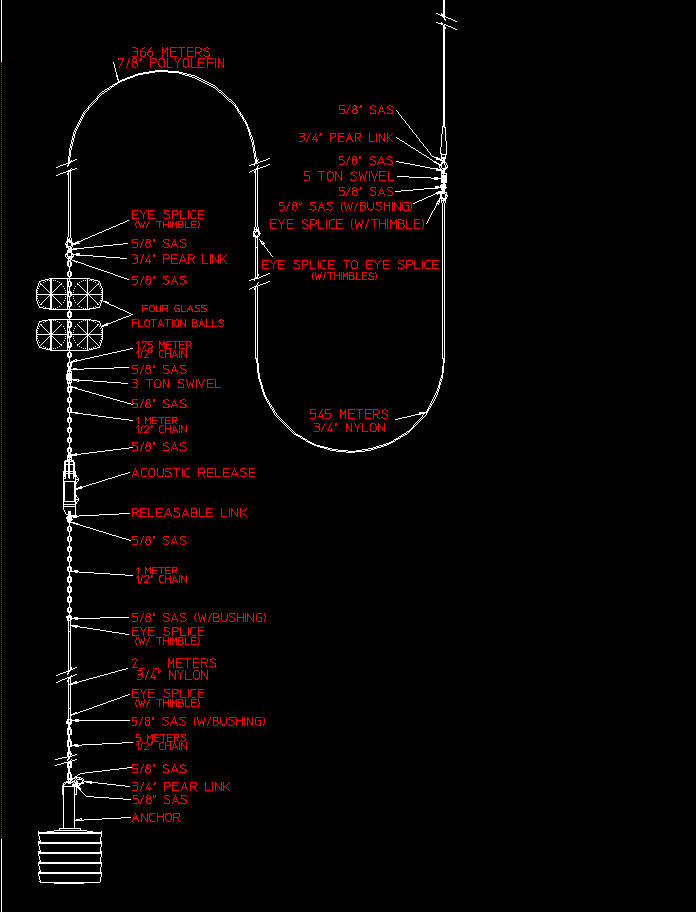
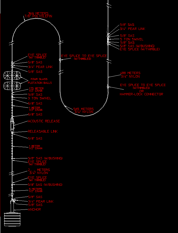
Diagrams of mooring M1 and M2: